Published: Mar 2, 2019 by SPAMLab
Between February 25th and March 1st (2019) we had a field trip to the Beautiful state of Santa Catarina, in southern Brazil. Our goals were to acquire Terrestrial Laser Scan (TLS) and UAV data of the Siriú Dune Field, located just north of the Garopaba city.
Back in 2010, we got an airborne LiDAR survey of the dune field, so now we want to evaluate dune migration by comparing the DEMs of 2010 and 2019.
The trip was quite long, Garopaba is 750km from São Paulo, and since only one of us could drive the university’s car, it took almost 12 hours to get there.
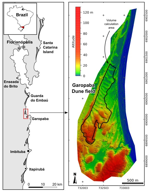 |
|---|
| Location of Garopaba, and the DEM from 2010 airborne LiDAR (Grohmann & Sawakuchi 2013) |
Once there, we had only three day of work, so we couldn’t waste time. The weather wasn’t perfect, there were a few dark clouds looming above us, but hope is something we always cary in our backpacks.
We started by setting up a DGPS base station at the highest point of the dune field, and assessing our situation: a lot of ground to cover, not much time to do it.
 |
|---|
| Dune. Arrakis. No, wait. |
It started raining just as we started setting up the GPS station (of course). It was a light rain so we continued, even though we needed an umbrella to be able to use the GPS control unit (tip: touchscreens and rain are not a good mix).
 |
|---|
| umbrella. |
The rain kept on-and-off, and after setting up some permanent markers for georreferencing, we started working with the laser scanner. This turned out to be harder than anticipated. Given the very irregular topography, we needed to make more scans than what we had planned in the office. The FARO scan is very esy to use and quite fast. We set the scan parameters for a resolution of about 6mm (at 10m distance from the scan) and without taking photographs, which resulted in 3-4 minutes for each scan.
 |
|---|
| Like |
Expecting more rain for the afternoon, we took the lunch break to go to the city and buy a large beach umbrella and some raincoats, to keep us the scanner safe from rain. Confirming our weather-predicting powers, the rain caught on in the afternoon, and we had to take shelter under the umbrella.
 |
|---|
| Honestly, the main reason I had to buy this large umbrella was because it matches my jacket. But it was usefull in the end. |
After the rain we even made a new friend. A hyperactive dog who was so happy with all that space and sand to play he couldn’t stop running around. Eventually it calmed down (for about 47 seconds) and helped us to guard the scanner.
 |
|---|
| A surveyor’s best friend. |
The second day of work was quite similar to the first: dark clouds passing by, intermittent rain, and a lot of work. At least there was some time to appreciate the view while the scanner was running.
 |
|---|
| So far I just can’t see… |
While Alynne, Guilherme and Rafael continued the scanning, my task was to set ground targets and fly the drone. The targets were positioned at the permanent markers were we collected DGPS data the day before. It took six missions to cover most of the dune field.
 |
|---|
| Learning to fly |
In our final day in the field, the sun came out (of course it did). We had only a few more scans to run and I took the opportunity to shoot some videos with the drone.
 |
|---|
| Look mommy, there’s a drone up in the sky |
Then I had to learn how to use non-linear video editors to make a clip. I’m getting there, and the result is on YouTube:
We slept the last night in Florianopolis, so the return trip was slightly shorter, only 11 hours driving. We all got back safe and with a lot of data to process!
 |
|---|
| Us. |